Software Review
TrailRunner 3.3.627

Function: Helps runners plan routes.
Developer: Berbie Software
Price: Suggested donation of €25
Requirements: Mac OS X 10.5
Trial: Fully-featured
I am not much of an athlete, but in recent years I got into running. I like running because it does not require much gear, at least the way I do it. Dress for the weather and put on a pair of shoes, then you are ready to run. However, I am particular about tracking my routes and distances covered. I avoid using a GPS because I want to run really light. I don’t even carry a music player and relish the idea of not having to worry about headphones and charging devices. For a while, I made do with Google Earth and a spreadsheet in Google Documents; then I was introduced to dailymile.com.
Recently, I found out about TrailRunner for Mac OS X even though I was already comfortable with dailymile’s tools. TrailRunner is free to download and is fully functional, so there is no harm in trying it out. However, lately, the software has started to nag about donation every time it’s launched. Even worse, you have to stare at the reminder a few seconds before the Continue button is clickable. The longer you have the software, the longer the wait. With my wait time now at five seconds, I do wonder what the maximum wait time is.
Installation
As TrailRunner usage involves physical activities and traveling on roads, it’s not surprising that the first time you launch the application you must confirm that you agree to the license agreement. This is just a way to protect the developer from being sued in case a runner gets hurt on too long a trail or a cyclist gets hit by a car.
Usage
The first thing I did with TrailRunner was to enter the few routes that I run every week. When I first started running, I made loops around a local park, but I easily lost count after a few loops. I then switched to running X miles out and then retracing my steps. The figure below is the result of one route recreated in TrailRunner; it is in the shape of the letter J. In Routes mode, I clicked the left-most tip of the J as the starting point, then clicked some more points along the route until I reached the turnaround point. As expected, as I clicked the few points, TrailRunner made the connections automatically. Lastly, click on Return To Start and had my out-and-back route.

One of the routes I follow. Out and back instead of X times around, say, a park, because I lose count easily.
There are a few background maps to choose from: Roads, OpenStreetMap, Topographic, Terrain, and Satellite. I use Roads and Satellite. Roads works most of the time, but Satellite comes in handy when I run along a waterfront and use a bench or other object as a point of return. Topographic and Terrain seem to work only when zoomed out; if you get any closer, you get no data at all. It’s not TrailRunner’s fault, but it’s worth mentioning.

TrailRunner can use five different background maps, although I use Roads most of the time and sometimes use Satellite.
Once you create a Route, you can add Activities to it. Activities are stored in the Diary, where you can add a Description to each Activity or the type of workout involved. You can also add workouts in the Diary that don’t use an existing Route (e.g., 12 times around an athletic track). From the Diary, you can then publish to MobileMe or an FTP site.
I think it’s a glaring omission that TrailRunner does not publish to Facebook or Twitter, or perhaps to some other sports-related social media. As a long-time, not necessarily diligent, blogger, I know how ineffective a blog can be. I can, and do, post the same material to my blog and to a Facebook Note, and most of the time the Note gets some responses. But I’m pretty sure a blog entry about my runs won’t garner much exposure.
If you want to see trails other athletes in your city or town follow, give the Community feature a try. TrailRunner supports trails or routes created by users of GPSies.com, Everytrail.com, and WikiLoc.com. Be warned, though: user-generated content can be chaotic and such is the case with TrailRunner. Trails can have too many turns such that you will not remember where to turn, or cryptic names that you have to wade through to find any decent ones.

Give the Community feature a try if you want to discover new routes used by others.
Running gadgets are very popular these days, and TrailRunner supports them well. The Nike+ SportBand can be synced to TrailRunner as well as Garmin data, plus a few applications from the iTunes App Store. As I don’t use any gadgets or apps, I can only say that the list of supported devices and apps looks good. Maybe some day I’ll change my mind about my tracking method and will revisit TrailRunner.
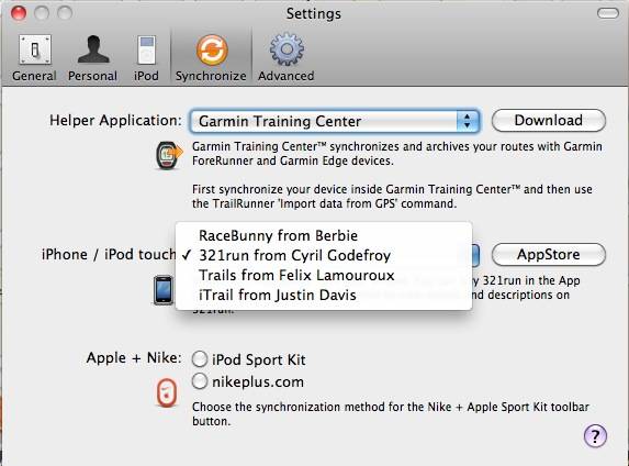
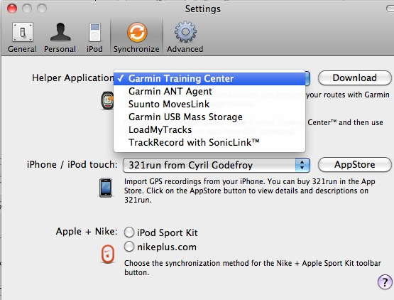
TrailRunner supports the Nike devices and iOS apps.
I love the Mac and also love running. I want to extend that love to TrailRunner, but I can’t. My primary use of TrailRunner is to record the distance I run on a given route. There are a few lacking features, as well as existing features, that don’t work well.
Most of my routes are out-and-back. (In other words, I run to a turning point then trace my way back.) I may run on the opposite side of the road on the way back, or maybe one block over, but the route is basically a line and not a closed loop. TrailRunner cannot properly draw an exact out-and-back line. The function that does this (labeled Return To Start) works for loops when the last marker put down is close to the beginning point. In my mind, when I reach the turnaround point, I should be able to tell TrailRunner to return to the beginning by traveling the route in reverse, exactly—not finding a different route back. The figure below shows the wrong route that TrailRunner drew for one of my waterfront runs.

TrailRunner needs to have a function that traces a route back to the beginning, exactly—not taking some extra distance to form a loop.
While I can live without an out-and-back feature, there is a feature that I really need to use but is not available in TrailRunner. I prefer running in places with little or no vehicular traffic, such as parks or boardwalks. While gmap-pedometer.com and dailymile.com cannot properly handle the connection from roads to beach, etc., they both have the option to stop following the road. It is very handy to freely draw the path. No such option exists in TrailRunner, so I was not able to create the route where I entered Kaiser Park, as shown below. TrailRunner has a button whose help bubble seems to indicate free drawing onto the map, but the button is not selectable. Just a simple on/off toggle to follow the road would be perfect.

Runners don’t always run on roadways. Let them roam free with the option to Unfollow Road.
Another issue I have with TrailRunner is the way distance marks are applied to the route. With dailymile.com and such, as I draw the route, whole numbers such as 1, 2, and 3 are added to the path to indicate that the distance was reached. The exact distance covered so far is shown on the same line as the route name.
With TrailRunner, each time you lay down a marker the distance shown is that between that marker and the previous one. Depending on how often you lay down the markers, at first glance, as if the distance gets shorter as you progress, a very confusing presentation. All along, you don’t know the total distance covered to that point; only after you’re done drawing the route do you have that information. Whenever I seek out new routes, I want the distance to be about the same as the distance I normally cover, say five miles. If I use TrailRunner, I don’t know at which point I will reach the goal of five miles until I click Finished.
Out of Breath
I know many runners and cyclists who carry mobile apps and gadgets. For those people, TrailRunner may be a good fit, as it supports various apps and gadgets. I may be one of the few people who run without devices and feel that TrailRunner is not for me. I would like the convenience of not having to draw my route completely; rather, I’d like to simply click a button to trace my way back to the beginning. I want to be able to draw my route without actually following a road. I also want to be able to measure distance in absolute terms. TrailRunner’s meager support for hooking up with social media does not help—neither does the constant nagging about donation.
![]() Copyright © 2011 Linus Ly. Reviewing in ATPM is open to anyone. If
you’re interested, write to us at reviews@atpm.com.
Copyright © 2011 Linus Ly. Reviewing in ATPM is open to anyone. If
you’re interested, write to us at reviews@atpm.com.
Reader Comments (0)
Add A Comment