Software Review
RouteBuddy 1.1.1

Developer: RouteBuddy
Price: $100 for application; $40-70 for various maps.
Requirements: Mac OS X 10.3.9. Universal.
Trial: Fully-featured (watermark and maximum of 30 objects).
As best I can tell, RouteBuddy is the first (and only, at this moment) mapping application for Mac OS X that allows you to connect a supported USB-enabled GPS device and interact with a live map display. Mac users have waited a long time for a single application that accomplishes this function with no extra software or hacks.
Unfortunately, RouteBuddy is not one of those rare “perfect-out-of-the-gate” version 1.x products. While I applaud that Mac users finally have this kind of tool, the application still feels as though it’s a beta—unfinished. I wavered between a Good and Okay rating, but sided for Good only because RouteBuddy does accomplish its core functions very well. The quality of map and point of interest data is excellent, using data from Tele Atlas, which is also used by Google Maps and Google Earth. The live tracking is responsive and accurate. Also, the recent version 1.1.1 update will make Geocachers happy thanks to the addition of .LOC and .GPX waypoint support.
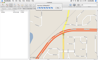
Recording a live track. Be sure you set your desired zoom level before recording, because you can’t change it until recording is done.
Performance
Topping the “bad” list is the application’s sluggishness. I might feel differently if I were on a brand-new Intel-based Mac, but a 1 GHz PowerBook G4 with a GB of memory ought to have enough oomph for RouteBuddy. I even tried running in a fresh user account to make sure none of the items I normally run were bogging things down, and moving around a map still felt like I was wading through molasses. If I clicked and dragged the map to slide it in a direction, I’d only go a few dozen pixels before I saw the blue “Loading” region and had to sometimes wait 10–20 seconds or more for that portion of the map to load and be displayed. Google Maps downloads this data from the Internet before it can display it to a visitor, but it manages to do it quickly. Shouldn’t accessing it from a map data file on a hard drive be even faster?
Routes
Creating a route is an exercise in patience. The time RouteBuddy takes to calculate which roads to follow after marking a route is no faster than map loading time. Even Garmin’s MapSource on my very old and slow Pentium II calculates routes faster.
The quality of the route can leave something to be desired, too. Sample routes that I created often took me through completely out-of-the-way roads. In one case, it even had me leaving a highway to go through residential streets and return to the same highway not far from where it veered off!
The worst part about route creation is the inability to use the zoom tool and hand slider while defining the route. If you switch to one of those tools, you’ll completely lose your route setup, forcing you to start over. Yes, you can zoom with the Command–Scroll Wheel feature using a mouse, but if you aren’t using a mouse and have an older PowerBook that predates the trackpad scroll feature, you’re out of luck.
Regardless of whether you have a mouse, the only way to scroll the map around while in the middle of defining a route is with the window scroll bars, clicking the arrows or the scroll area to move one bit at a time. Beware of dragging the scroll widgets. The scroll bar area represents the entire map. A few pixels worth of scroll bar drag and, whooooosh, you may find yourself going from Orlando to some nowhere spot in the middle of Texas!
Here’s the best way I found to fine-tune a route: first, define standalone waypoints in advance that will be points you want to pass as part of your route, including the beginning and ending points, then zoom out and create a general estimate of your route just with temporary starting and ending points. Don’t even worry about being accurate with them. Next, double-click the route and use the panel that appears to add and rearrange your previously created waypoints, including correct start and end points. Feel free to delete the rough start and end points afterward.
Remembering Window Locations a Bit Too Well
Those who use a second monitor attached to a laptop must be wary about leaving a map window in the second monitor. I took my laptop to the car and discovered, after booting it up and launching RouteBuddy, that my default map window was not visible. Apparently, RouteBuddy saved its position on the second display and was still trying to put it there, even though the display wasn’t attached. This is not a Mac OS bug. I repeatedly leave my Safari browser window on my secondary display at home, and it dutifully resets to the primary laptop display when I boot up while out on the road.

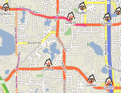
The iTunes-esque bread crumb buttons were often useless. All of my RouteBuddy testing was done in the western and northwestern regions of metro Orlando, in Orange and Seminole Counties. The buttons, as seen above, almost always indicated I was in central Volusia County.
Document Corruption
Also on the bug list is a condition I encountered that no longer allowed me to save a map document file. I suppose it somehow became corrupted. The only way I could close it (or even quit RouteBuddy) was to not save that map window. I don’t, however, think this was RouteBuddy’s fault. I discovered today that my Garmin’s USB jack has recently become damaged and will no longer make a reliable connection. My repeated attempts to keep the USB cable attached probably confused RouteBuddy. Several times, this problem of mine caused RouteBuddy to crash—possibly corrupting my document file. Fortunately, I was able to keep a connection long enough to record a sample track, seen in the first figure, above.
No Address Data
If you’re using a route as a guide to drive somewhere, you’d better have a navigator in the car who can focus on the computer and tell you when a turn is approaching. I found no function for turn-by-turn directions—something that should be added. Mac OS X has a built-in speech synthesizer—why not use it to announce upcoming turns? The reason might be that there doesn’t seem to be any street and address data in the maps. This probably explains why, as stated earlier, a route I created needlessly took me off of a highway. Considering the price tag of the maps, I definitely think this data should be included. Users should be able to type in a street address to have the map hone on that area.
Tool Bloat?
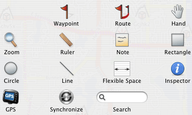
I’d love for someone to tell me the purpose of the Rectangle, Circle, and Line tools because I’m at a loss. They can’t be labeled, and they don’t seem to interact with any other part of RouteBuddy that I can see. The Note tool might be a bit more valuable, but you have to click on the note to read it. In addition to the regular note, it should have a title field that appears beneath the icon, just like regular waypoints.
Paltry Toolbar Item Availability
In the case of RouteBuddy’s toolbar, more would definitely mean better.
First of all, at least two (or more) standard OS X toolbar items are not available—Space (as opposed to Flexible Space) and Separator. A toolbar Customize button is also missing, which I believe is normally always available. Since RouteBuddy has printing functions, it stands to reason the Print button should also be present. On second thought, maybe it shouldn’t. Two attempts in a row to use the standard “Preview” function in the Print window (I don’t own a printer at home) resulted in RouteBuddy freezing, requiring a Force Quit.
Besides these OS-standard toolbar buttons, there are numerous RouteBuddy functions that I’d love to have available in the toolbar, such as recording a track; accessing the Device, Inspector, and Navigator windows; zooming in, out, and to fit; the point of interest locator; and the various “Go To” items.
Scorecard
I had high hopes for RouteBuddy. I’ll admit that my hopes were perhaps too high and that I’m being too harsh in this review. But I can’t help but be harsh when I found myself wishing I had an old PC laptop so I could use Garmin’s Windows-only MapSource application while on the road instead of RouteBuddy. I’ll also admit that even though MapSource is the only application that can sync maps into my Garmin GPSMAP 60CS, and I feel that it outperforms RouteBuddy, MapSource pales in comparison to Microsoft Streets and Trips. That’s right, your conclusion is correct. I really am suggesting that Streets and Trips is substantially better (and cheaper) than RouteBuddy. But that is moot since Streets and Trips, like MapSource, is only available for Windows.
We Mac users like to think that Mac software is superior, right? OK, that’s not a universal truth, but we still like to think it. With that mentality, RouteBuddy should be looking at the best equivalent product on the Windows platform and aspiring to be even better. RouteBuddy may never be able to approach the selling price that Streets and Trips users enjoy (Microsoft could quite justifiably charge more for it), but I see no reason it couldn’t reach and surpass the user experience.
![]() Copyright © 2006 Lee Bennett, lbennett@atpm.com. Reviewing in ATPM
is open to anyone. If you’re interested, write to us at
reviews@atpm.com.
Copyright © 2006 Lee Bennett, lbennett@atpm.com. Reviewing in ATPM
is open to anyone. If you’re interested, write to us at
reviews@atpm.com.
Reader Comments (25)
I'm going to check it out and will report back here (if not in a future review). My last impression of MacGPS was that it didn't support USB and was a bit kludgy to set up. I said in this review that RouteBuddy was the first (to my knowledge) to have a simple solution of downloading the application, installing a map, connecting your GPS, and boom.
Even if MacGPS Pro supports USB on my particular model, I have a daunting feeling about their method of providing maps. Sure, many of the ones for MacGPS are free, but there are gobs of links and no real guide as to which one is best for my needs. A GPS veteran may easily be able to tell, but a newcomer is completely lost. It's like MacGPS developers just pull down an old dusty box from a shelf and dump out the contents on the floor and tell you "here, find yourself a map."
http://web.mac.com/francoborgo/iWeb/MacMobile/Software.html
There is another solution that combine Google earth and two others softwares but I did not put it on my Website yet.
Franco
For what it's worth, I'm not personally interested in any application that utilizes Google Earth because this is a tool I would want to use on the road. I neither have, nor care to invest in the monthly fee for, a mobile internet card, so I would have no way to do a live track on Google Earth since I'd have no internet connection.
MacGPS 'umm "Pro?" (now who's kidding who here?), yeah ok it's a one man hobby built program that tries to do everything for walkers and sailing use but never gets it quite right. Being realistic, MacGPS Pro is a primitive application and very rough around the edges, with an OS 7 carbon interface that's been cobbled up to work in OS X and then it can't even talk to some of the newer Garmin devices like my Streetpilot!! Yes it is worth $50 for picture mapping but that's where it ends, road mapping it just don't do!
MacGPS Pro, should be re-named as MacGPS Topo as it can't even make a drive route, or use vector road maps which without gives little use for me in my RV or Jeep and it only uses picture maps which you then have to spend time getting coordinated in a frustrating and time wasting manner, in fact it's so kludgy that they don't even give you a free demo trial and you have to pay for it upfront in the hope that you won't ask for your 50 bucks back!!! If RouteBuddy keep adding free features, get their routing sorted as they have stated they will on their forum and start to offer topo maps like MacGPS Pro then we'll have two good modern and real OS X programs for Macs in GPSNavX and RouteBuddy. My support for what I want in the future goes out to the guys who really "know" what a Mac OSX program should be like!
Route66 is old, way old, so a reality check means if they produce a new version with uptodate maps then expect a price hike. Will it still be a PC port - bet it will. Will it connect easily to receivers - doubt it.
Google Earth? OnThe Road?? Try checking out the detail outta town and see what you're not gonna get! And as Lee says you gotta pay for online access too! If you want to work both ways with Google and a GPS then that's not free either at $400 a year!!
Free software means free hassles. Sounds like this is a Linux posting board now ;-)
I'd never heard of Route66, maybe due to its age.
As for Google Earth on the road, sure there's no visual detail in rural areas, but the road data is just as up to date as anything. It would be a good solution if you already used the mobile internet service.
http://roadnav.sourceforge.net/index.php
Virtual Keyboard, Spoken turn by turn Direction, Night or Day set-up, 3D view, Software and US map Free.
____
I agree with the fact that I wont use Google Earth but you dont need an internet conenction. First, you just need to cache the data while online and then use it off-line. Not the kind of solution I am looking for.
Franco
Franco, I appreciate what you say in your advertisment but Tiger Line Data is old and basic. Free data equals free hassle, there ain't no such thing as a free lunch! Anyway RoadNav is a hobby/community app and I want the support of a real company that will look after me if I had any hassles and who will carry on developing a product. I look down on Linux style freeware and the grief you get, RoadNav smacks of another cheap freebie for all platforms and an app that slowly goes nowhere :(
Lee - I checked out the speed on my PowerBook in my RV and I think you need some extra SDRAM there, you may have been a little unfair / inaccurate in your comment on speed.
I buy mine from Crucial.com, it's reasonable and they offer a great service!
Adam
Caching Google Earth data? I've never heard of that. How is that accomplished? Yeah, maybe not a solution, but I'm very curious on cache settings.
Adam - I'll be quite honest here—I live in the states and have not yet had the opportunity to go outside the US and Canada, so I could never claim knowledge on the quality of road data for Europe.
I'm also not going to invest money into more RAM for a PowerBook that I hope I don't have much longer—if I can find a way to afford an MBP.
But I do feel fair in my speed comment. RouteBuddy's web page only lists OS X 10.3.9 as a minimum requirement. If a faster CPU and more RAM are needed for it to operate smoothly, the recommended system requirements should say so.
Works fine on my G4 tower and powerbook with the latest Tiger 10.4. Not perfect but have used several different GPS with it. Had to do a little experimenting with drivers with a couple but got them all to work. Can't see any reason why a bluetooth GPS won't work fine. Have heard that the factory support is lacking but have not needed it. Will work on all OSX. Make sure to get the Mac version.
Have not checked out the www.route66.com link in a while. For FAQ and support, go to: http://www.66.com/route66/support.php?cid=US and click on faq, select route, select Mac OS and it gives the answer to a lot of question, which gps units will work, links to drivers, etc. I did find new and used versions as well as 35 reviews at http://www.amazon.com/Route-66-USA-2004-Mac/dp/B00013MS7O The 2.5 rating is about right. I also neglected to say that mine is also the 2004 edition. I did use DeLorme's version on OS9 with their earthmate and it worked OK but no support for OSX. I am now using a Holux GPSlím 236. Check the review at http://www.aximsite.com/articles/link.php?id=255 It is a bluetooth receiver with an optional USB cable (the one that comes with it only supplies power to charge it). It is one of the new SiRF gps receivers with 20 satellite channels. It has outstanding reception. I can leave it anywhere inside the car or the middle of the house and it lock onto the satellites really well and quickly. Battery lasts over 10 hours and it is tiny. Have had a problem with the power switch so it is back east getting fixed now.
More about the Route USA:
The good.
Really cheap!
The only thing I have seen to work on OSX
The map has a pleasant appearance with a mild topo look. You can also change colors on the display.
You can zoom in on a city anywhere and see the one way streets and addresses by the hundred blocks in a lot of places.
The so so: A bit slow.
The bad:
No voice
Maps out of date (my Magellan 760 and my TomTom 6 are not much better)
Tries to send you down blocked off or small streets that are out of the way or slower. Streets and Trips, Magellan and TomTom all do the same thing.
Lots of other little deficiencies you will find as you go along (they ALL have them, some less, others a lot more) Takes a while to add up the +/-s.
The designer was a windows fellow. Probably will please windows people better (where everything is generic at best).
Of course, the big problem with any of these whether you are using a Powerbook or a PC laptop, is the fact you need a second person along, especially in the daytime. Sunny days make the screens unreadable. They do work well in a motorhome were you can get more shade. For that reason I use my Palm or Magellan when I am by myself. Much safer to drive with a small screen right in front of you than trying to read a big, unreadable screen on the seat next to you.
I do have a PC laptop with MS Streets and Trips 2006 on it. The review at Amazon is about the same, 3 stars: http://www.amazon.com/Microsoft-Streets-and-Trips-2006/dp/B000AOBSTS
The software is not nearly as good as the Magellan or TomTom. Both have Mac installers for a palm (with the older TomTom, you have to go to the site and download the patch or it won't install)
My only other comment is that Route 66 is based in the Netherlands. Because of the very low population growth in europe, the maps don't get out of date nearly as fast. Plus, europe is home to the Route 66 company.
About RouteBuddy: Seems really overpriced like Garmin maps, etc. Especially after reading the poor reviews on it so far. $20 gets you a copy of MS streets and trips on ebay (if you have a MacBook with XP on it).
Now, if only someone would do Mexico.
Please write with anymore questions.
Best regards,
Pierce Stewart
Subsequent discussions with the RouteBuddy developer suggested that I would not have experienced the performance issues on a slightly beefier machine. While I'm not convinced another gigabyte of RAM beyond the 1GB I have would make much difference, it's definitely plausible that a MacBook or MacBook Pro would probably not experience any sluggishness at all. My feeling is that if an Intel-based Mac is required for a responsive interface, then it should be listed as a recommended system requirement. Currently, RouteBuddy's web site only states that OS X 10.3.9 is required. Nothing about CPU or RAM.
http://www.mp3car.com/vbulletin/showthread.php?t=90035
To use Google Earth without internet connection you can read this Google Earth how-to FAQ. He use a free program that he wrote to cache the data before the trip.
http://www.mp3car.com/vbulletin/showpost.php?p=772426&postcount=8
There was a more complete solution with Google earth that use Turn-by-turn direction etc. You can read another complete report on GPSRouteX. (The web site to GPSRouteX does not respond...)
http://www.mp3car.com/vbulletin/showthread.php?t=85612
None of the GPS software for the Mac that I listed on my web site are real navigation software. My hope is on RouteBuddy but it has not reach that level yet.
I could buy an Intel Mac and use PC software on top of MacOS X or buy an extrenal GPS navigation system with 7 inch touchscreen and 30 GB HD for MP3 for 500 $ can this one:
http://www.nextar.com/frontend/proddetail.asp?pn=MN2607&co=10000312
But right now, I still use Route66.
When I can set aside the time, I'm intending to submit a new review. If it doesn't make it in the March issue, then possibly April.
Best regards
Harald Lohmann
(RouteBuddy 1.x is a discontinued product.)
Let me know here: support@RouteBuddy.com if we can assist any further.
Best,
Neil
http://tinyurl.com/RouteBuddy-Download
The new version of RouteBuddy works with vector Road Maps *and* raster Topo Maps: http://www.routebuddy.com/news/
First USGS Topo maps are now available from our store:
http://store.routebuddy.com/maps/north_america
http://www.routebuddy.com/atlas/index.html
Use our USGS derived Topo maps in your iPhone and on your Mac!
Unless, someone has the facts to show me that I can map myself from my home to a location of my choice across Canada or US, and the program actually creating a route, why should I "have" to know where my destination is? Is that not the idea of a mapping program? To get me to an unknown location? This is a sad excuse, UNLESS someone proves to me otherwise!!!
I'm not sure what you mean by "it does not do the trick"; If you have problems with our software then a short email to support@RouteBuddy.com will get a fast response to help you through getting started.
A standalone program (or offline app) is one that uses maps without requiring maps from the internet. RouteBuddy can be used with or without a GPS; you only need a GPS if you want to track or navigate. I agree that a GPS has to be compatible but that is down to the manufacturers who have always been PC-centric; The reason we always recommend www.usglobalsat.com is because they have supported the Mac community for many years with their GPS devices and software drivers.
If you wouldn't mind writing a support ticket in to Jannion at RouteBuddy then she'll help you so that you can get the best out of RouteBuddy for Mac or RouteBuddy Atlas for the iPhone.
Best,
Neil
Do NOT waste your money on RouteBuddy. Google Earth is FREE and it does a great job calculating routes. Plus, you can view intersections from the viewpoint of sitting in your car for the entire route. Google Earth files can be saved as KML files.
HoudahGPS is a FREE gps data conversion software. Garmin Basecamp is a FREE software that interfaces with the GPS.
Spent 3 hours trying to create a route and I have experience using this software. Google Earth did properly in 10 seconds.
Please contact us with details of the route you were trying to create and also let us know your purchase information and what version of the map and software you are using as our rendering speeds have been greatly improved with the caching of tiles for some of the larger maps.
RouteBuddy's UI and tools have been kept very clean, and there is comprehensive manual for those who choose to read it. Or are you still referring to DeLorme software? (tinyurl.com/yzk9bnn)
If you have a fast Mac (but you don't mention the full spec...) and you have a problem with rendering/routing then what you should do is send your full details, and sample routes to Support then we can try to assess what exactly is going wrong; Either in our software, or on your Mac - it's not always 'just' the software. I think we have asked for a response on this before and, if we have no feedback, then we are not in a position to help.
RouteBuddy deletion works in exactly the same way as deletion in iTunes - so you don't accidentally delete something.
Google Earth does not calculate road routes, nor does it work with Garmin and Tom Tom devices as RouteBuddy does.
Google Earth needs a live internet connection to operate, and a sizeable amount of bandwidth; 'If' you should be able to get (and keep) a connection in your car on the move, then the rendering would be slow and patchy; The data costs would also be prohibitive.
RouteBuddy saves files as .kml files, as well as multiple others that GE doesn't offer or support.
HoudahGPS is limited-use GPS data conversion software, without a map, or all of the other features RouteBuddy offers.
Garmin BaseCamp is not free; You have to buy a topo-map to get it, and at a much higher price. Furthermore Garmin Topo maps are nowhere near as detailed as the USGS Topo maps that RouteBuddy offer.
Please send your sample files into support@RouteBuddy.com - then we can look into it.
Thanks.
neil
Add A Comment